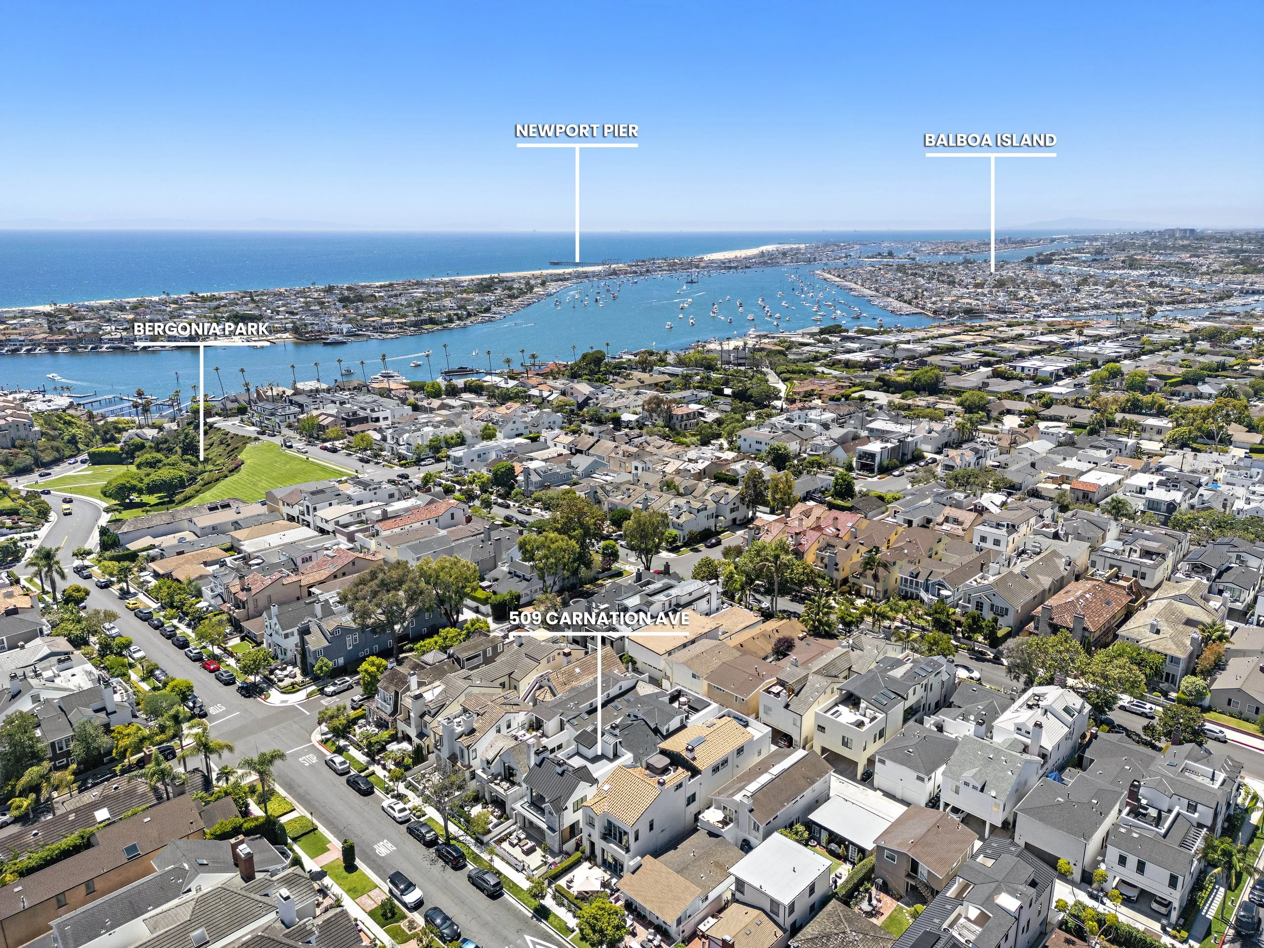
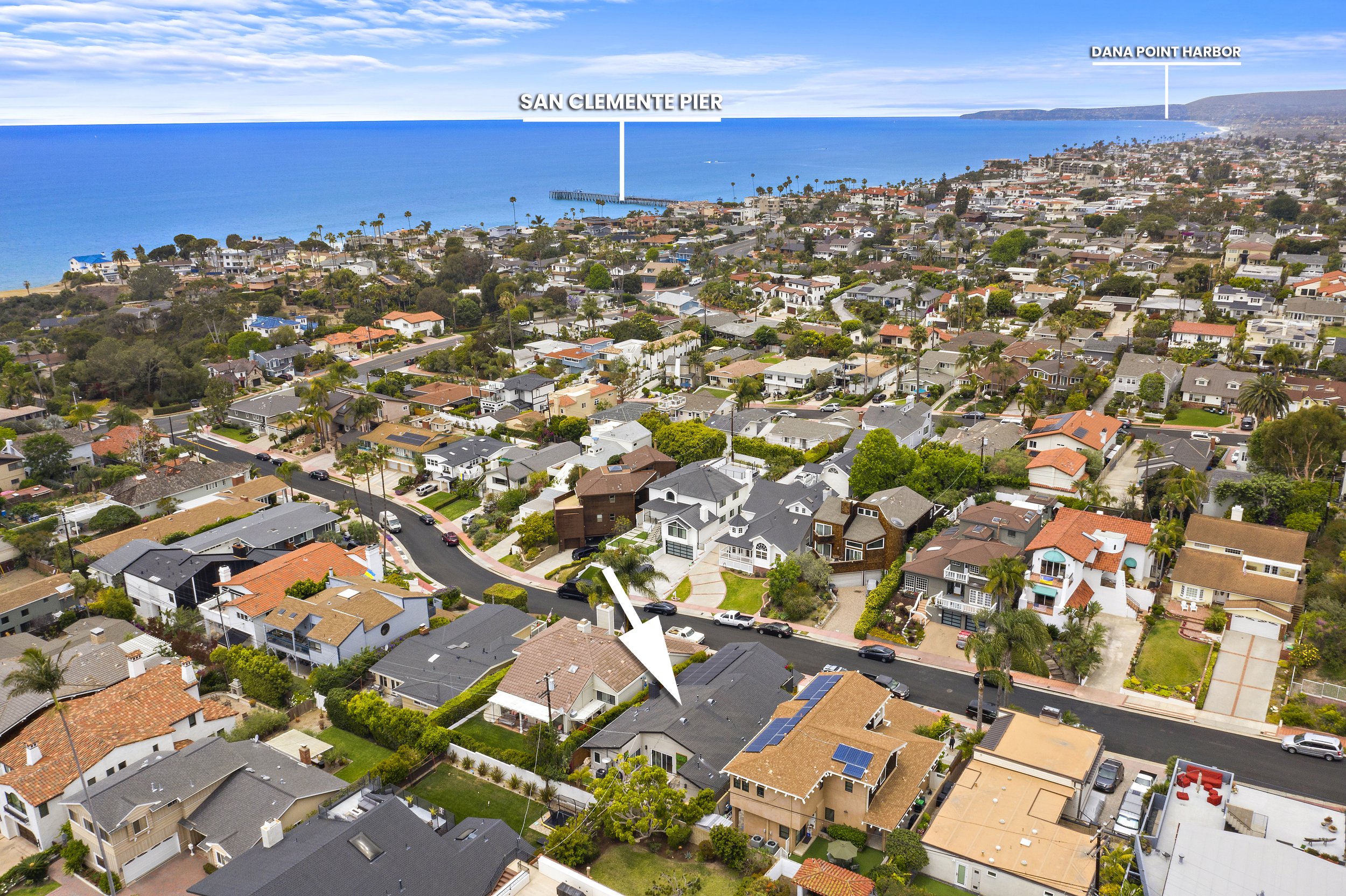
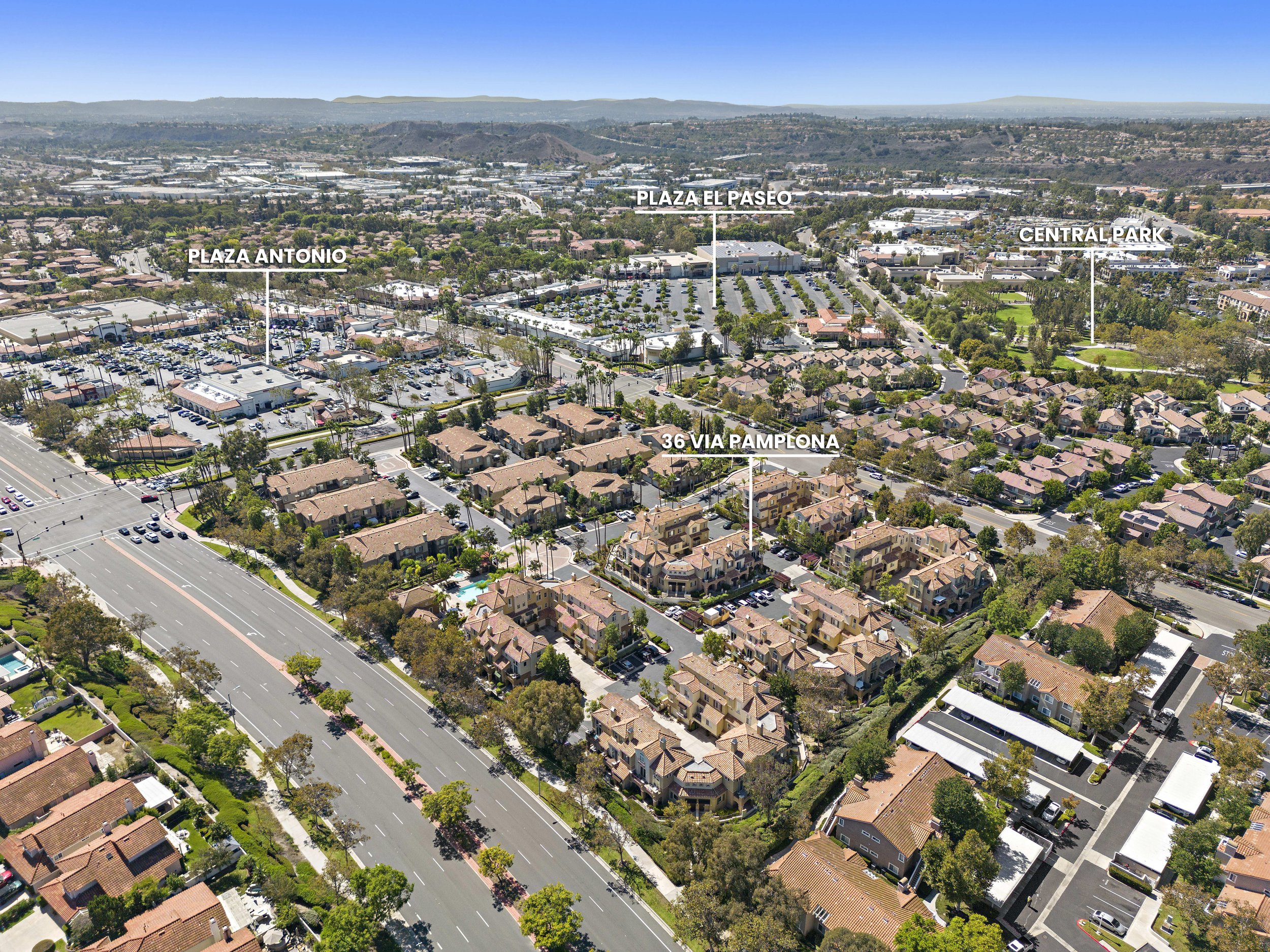
0
Skip to Content
BOWMAN GROUP MEDIA
PHOTO
VIDEO
3D
ADD-ONS
ABOUT US
RESOURCES
FAQ
TUTORIALS
CONTACT US
BOOK NOW
BOWMAN GROUP MEDIA
PHOTO
VIDEO
3D
ADD-ONS
ABOUT US
RESOURCES
FAQ
TUTORIALS
CONTACT US
BOOK NOW
PHOTO
VIDEO
3D
ADD-ONS
ABOUT US
Folder: RESOURCES
Back
FAQ
TUTORIALS
CONTACT US
BOOK NOW

POINTS OF INTEREST GEOTAG

52-print-438 Cypress GEOTAG .jpg View fullsize
55-print-15 Via Barcaza GEOTAG.jpg View fullsize
56-print-509 Carnation GEOTAG .jpg View fullsize
75-print-522 High 12 GEOTAG 2.jpg View fullsize
51-print-3909 Carta De Plata GEOTAG 1 (1).jpg View fullsize
Aerial view of a coastal neighborhood with houses, streets, trees, and two labeled locations, San Clemente Pier and Dana Point Harbor, with ocean in the background. View fullsize
An aerial view of a residential neighborhood with labeled landmarks including Oso Grande Elementary, Oso Grande Park, and a street called 9 Chiante. The scene features houses with red-tile roofs, green trees, and mountains in the distance under a par View fullsize
Aerial view of a residential neighborhood with labels identifying local landmarks such as Arroyo Vista Elementary and Middle School, Arroyo Vista Park, 241 Toll Road, Tijeraso Creek Golf Course, and 4 Charca, with mountains in the background under a View fullsize
Aerial view of a coastal neighborhood with labels indicating Las Palmas Elementary School, beach access at 204, Dana Point Harbor, and the address 155 W Mariposa, showing houses, streets, and the ocean in the background. View fullsize
Aerial view of a residential neighborhood with labeled locations including Plaza Antonio, Plaza El Paseo, Central Park, and 36 Via Pamplona, showing streets, houses, parking lots, and green spaces under a clear blue sky. View fullsize
Aerial view of a residential neighborhood with a clubhouse and pool marked as Dana Vista, overlooking the ocean and coastline in the background. View fullsize
Aerial view of a suburban neighborhood with labeled parks and landmarks including Poets Park, 26 Tuberose, Oso Grande Park, and Oso Grande Elementary, showing residential streets, houses, and surrounding hills. View fullsize
An aerial view of a neighborhood with labeled landmarks: St Junipero Serra Catholic School, 241 Toll Road, Tijeras Creek Golf Course, and 4 Charca, with houses, trees, a pond, and distant hills. View fullsize
Aerial view of a residential neighborhood near the coast with houses, streets, trees, and mountains in the background. Text overlays identify locations including 155 W Mariposa, Avenida del Mar, and San Clemente Pier. View fullsize
42-print-128 Via Vicini GEOTAG .jpg View fullsize
51-print-342 Sunrise 7 GEOTAG.jpg View fullsize
52-print-3909 Carta De Plata GEOTAG 2.jpg View fullsize
52-print-33025 Christina 13 GEOTAG 2.jpg View fullsize
53-print-3909 Carta De Plata GEOTAG 3.jpg View fullsize
74-print-522 High 11 GEOTAG 1.jpg View fullsize
74-print-20682 Porter Ranch GEOTAG.jpg View fullsize
81-print-22556 Charwood GEOTAG .jpg View fullsize
56-print-3007 Harbor View GEOTAG.jpg View fullsize
52-print-438 Cypress GEOTAG .jpg
55-print-15 Via Barcaza GEOTAG.jpg
56-print-509 Carnation GEOTAG .jpg
75-print-522 High 12 GEOTAG 2.jpg
51-print-3909 Carta De Plata GEOTAG 1 (1).jpg
Aerial view of a coastal neighborhood with houses, streets, trees, and two labeled locations, San Clemente Pier and Dana Point Harbor, with ocean in the background.
An aerial view of a residential neighborhood with labeled landmarks including Oso Grande Elementary, Oso Grande Park, and a street called 9 Chiante. The scene features houses with red-tile roofs, green trees, and mountains in the distance under a par
Aerial view of a residential neighborhood with labels identifying local landmarks such as Arroyo Vista Elementary and Middle School, Arroyo Vista Park, 241 Toll Road, Tijeraso Creek Golf Course, and 4 Charca, with mountains in the background under a
Aerial view of a coastal neighborhood with labels indicating Las Palmas Elementary School, beach access at 204, Dana Point Harbor, and the address 155 W Mariposa, showing houses, streets, and the ocean in the background.
Aerial view of a residential neighborhood with labeled locations including Plaza Antonio, Plaza El Paseo, Central Park, and 36 Via Pamplona, showing streets, houses, parking lots, and green spaces under a clear blue sky.
Aerial view of a residential neighborhood with a clubhouse and pool marked as Dana Vista, overlooking the ocean and coastline in the background.
Aerial view of a suburban neighborhood with labeled parks and landmarks including Poets Park, 26 Tuberose, Oso Grande Park, and Oso Grande Elementary, showing residential streets, houses, and surrounding hills.
An aerial view of a neighborhood with labeled landmarks: St Junipero Serra Catholic School, 241 Toll Road, Tijeras Creek Golf Course, and 4 Charca, with houses, trees, a pond, and distant hills.
Aerial view of a residential neighborhood near the coast with houses, streets, trees, and mountains in the background. Text overlays identify locations including 155 W Mariposa, Avenida del Mar, and San Clemente Pier.
42-print-128 Via Vicini GEOTAG .jpg
51-print-342 Sunrise 7 GEOTAG.jpg
52-print-3909 Carta De Plata GEOTAG 2.jpg
52-print-33025 Christina 13 GEOTAG 2.jpg
53-print-3909 Carta De Plata GEOTAG 3.jpg
74-print-522 High 11 GEOTAG 1.jpg
74-print-20682 Porter Ranch GEOTAG.jpg
81-print-22556 Charwood GEOTAG .jpg
56-print-3007 Harbor View GEOTAG.jpg

Book Your Shoot with Us Today!

BOOK NOW
BGM Logo White Text.png

© 2025 Bowman Group Media

 Privacy Policy / Terms of Service

SERVICES

Photography

Video

3D

Add-Ons

RESOURCES

FAQ

Tutorial Videos

Contact Us

Appointment Terms of Service

Travel Fee

Licensing Agreement

Cancellation Policy

Subscribe

Sign up with your email address to receive news, updates and special offers!

We respect your privacy.

Thank you!